
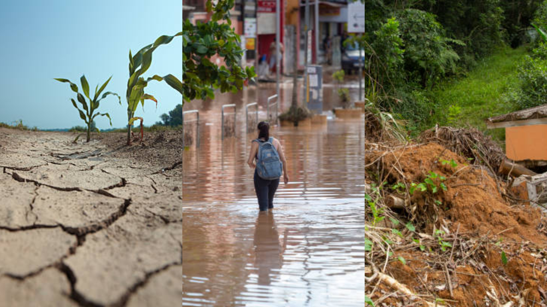
The El Niño phenomenon once again draws the attention of governments, producers, and communities across Latin America whenever its signals begin to emerge in the Pacific. Although it is often described as a single climate event, its effects are actually distributed very unevenly across Latin American territory. In some countries, it causes heavy rains, flooding, and infrastructure damage; in others, it worsens drought, raises temperatures, and reduces agricultural production.
The name “El Niño” has a simple but meaningful history. Fishermen along the Pacific coast, especially in Peru and Ecuador, noticed centuries ago that a warm current appeared near December, around the Christmas season. Because it coincided with the celebration of the Christ Child, they began calling it El Niño. Over time, that local observation became a global climate concept that now helps explain part of the region’s climate variability.
What Is El Niño?
El Niño is a phase of the climate system known as ENSO, short for El Niño–Southern Oscillation. During this phase, surface waters in the central and eastern equatorial Pacific become warmer than usual. That change alters atmospheric circulation, modifies rainfall patterns, and affects wind behavior in different parts of the planet.
Although the phenomenon begins in the ocean, its consequences are felt on land. El Niño can alter the agricultural cycle, water availability, hydroelectric generation, fishing, public health, and the stability of several ecosystems. However, it does not affect every country in the same way or with the same intensity. This is one of its most important characteristics: its effect is regional, but never uniform.
Why Is It Called El Niño?
The name has a popular, coastal origin. Peruvian and Ecuadorian fishermen observed that this warm current frequently arrived near Christmas, so they associated it with the Christ Child. At first, the term described only a local change in the sea, but science later adopted it to name a much broader phenomenon.
This history is useful because it reminds us that climate knowledge did not emerge only from laboratories. It also arose from the direct experience of communities that depended on the sea and knew how to read its changes. Today, technology allows scientists to measure El Niño with models, satellites, and ocean monitoring stations, but its name preserves that human and coastal memory.
A Map of Uneven Effects
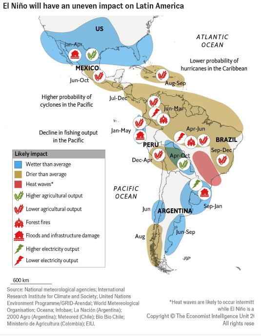
The map accompanying this topic makes one idea very clear: El Niño does not affect all of Latin America equally. In some places, it is associated with excessive rainfall; in others, with drought and extreme heat. There are also areas where the likelihood of wildfires increases, while others face declines in agricultural production or energy generation.
This diversity of effects requires a more precise approach to the phenomenon. It is not enough to say that “there is El Niño” and expect similar weather conditions across the continent. Each subregion responds according to its geography, its relationship with the Pacific or Atlantic, its altitude, its production systems, and its institutional capacity to adapt.
Mexico and Central America
In Mexico and much of Central America, El Niño is often associated with less rainfall during certain periods of the year. This can affect key crops, reduce soil moisture, and make access to water more difficult in rural areas. For communities that depend on rain-fed agriculture, a dry season is not simply an inconvenience: it can mean significant losses of income and food.
In addition, the lack of rain does not affect only rural areas. It can also affect urban life, as water reserves decline, prices rise, and public services face greater pressure. In this sense, El Niño has a clear social dimension: it does not remain a matter of weather, but reaches the everyday economy of thousands of families.
The Caribbean and the Likelihood of Hurricanes
In the Caribbean, the map shows a lower likelihood of hurricanes during certain El Niño episodes. That may seem like good news, but it should not be interpreted as an absence of risk. Fewer hurricanes do not mean less climate-related impact. The region may still face heat, irregular rainfall, and water stress.
For Caribbean islands and coastal areas, this variation is important because it affects agriculture, tourism, water consumption, and emergency planning. Moreover, even when the cyclone threat declines, people remain exposed to problems such as partial droughts, heat waves, and changes in soil quality. For that reason, the Caribbean’s overall situation during El Niño remains delicate.
Colombia, Venezuela, and Northern South America
In northern South America, the phenomenon often appears as drought, heat, and a higher risk of wildfires in several areas. That pattern carries a high cost for agriculture and ecosystems. When moisture declines, forests become more exposed, and fires find better conditions in which to spread.
Food production is also affected. Less rain means lower yields for sensitive crops and greater pressure on prices. In a context of economic inequality, this can worsen existing problems. For that reason, in this part of the continent, El Niño is not only an environmental issue; it is also a food security and land-management challenge.
The Amazon and the Interior of the Continent
The Amazon is often especially vulnerable when El Niño intensifies heat and reduces rainfall. The forest depends on a delicate balance, and any prolonged disruption can affect moisture, biodiversity, and the water cycle. When soil and vegetation dry out, the risk of fires increases and the ecosystem loses some of its capacity to recover.
This deterioration affects more than nature. It also harms Indigenous, farming, and riverside communities that depend on the forest for their livelihoods. In addition, it complicates river transportation, food supplies, and the safety of local routes. Thus, a phenomenon that begins in the ocean ends up influencing the lives of entire communities in the continent’s interior.
Peru and the Pacific Coast
Peru occupies a central place in discussions about El Niño. There, the phenomenon is closely monitored because it changes ocean conditions and, consequently, fishing. When surface water warms, several species change their location or become less prevalent in certain areas, reducing catches.
At the same time, some coastal areas may experience heavier-than-usual rains and flooding. This affects homes, roads, crops, and basic infrastructure. The paradox is clear: the same phenomenon that harms the sea can also disrupt life on land. That is why Peru is often one of the countries that best illustrates El Niño’s complexity.
Chile and the Southern Cone
In the Southern Cone, El Niño’s response can vary considerably depending on the area. In some sectors, moisture increases, while others experience sharper climate contrasts. This complicates agricultural planning and water management because not all territories receive the same rainfall pattern.
Argentina also appears on the map with diverse effects. Some areas become wetter during certain months, while others face drought or excess water at different times of the year. This combination affects grain production, livestock, rural roads, and, in some cases, hydroelectric generation.
Agriculture and Food Security
Agriculture is one of the sectors most sensitive to the phenomenon. When El Niño brings less rain, yields decline. When it brings too much, crops can also be damaged. Its impact on food production therefore does not always take the same form, but it is almost never overlooked.
In many countries, agriculture remains a highly important economic and social foundation. There, a poor climate season can translate into debt, temporary migration, job losses, and higher food prices. For that reason, monitoring El Niño is also a matter of economic security.
Energy and Infrastructure
Energy is another sensitive area. In countries that depend on dams and hydroelectric systems, less rainfall can reduce generation. Conversely, in regions where El Niño brings intense rains, excess water can damage roads, bridges, homes, and power networks.
This shows that the impact is not limited to rural areas. It also reaches hospitals, schools, transportation systems, and basic services. When infrastructure is weakened, everyday life becomes more difficult. For that reason, talking about El Niño also means talking about resilience, maintenance, and the state’s ability to respond.
What the Map Reveals
The map teaches an essential lesson: Latin America does not experience El Niño uniformly. The same event can mean drought in one country, flooding in another, and declining production in a third. That difference requires detailed analysis, regional planning, and decisions adapted to each context.
It also shows that risks overlap. In one area, agricultural production may decline; in another, wildfires may increase; elsewhere, the main problem may be water. This combination requires authorities and communities to stop thinking in general terms and begin working with greater precision.
How to Prepare Better
Preparing for El Niño begins with reliable information and timely decisions. Early-warning systems help reduce damage, but they work well only when governments, producers, and communities take them seriously. In addition, water management, crop protection, and infrastructure reinforcement must be part of a broader strategy.
In agriculture, it is advisable to adjust planting calendars, strengthen irrigation wherever possible, and diversify crops. In urban areas, drainage systems, water reserves, and electrical networks need to be reviewed. Socially, it is essential to protect the most exposed populations, which are often those with the least ability to withstand a climate crisis.
Conclusion
El Niño is a natural phenomenon, but its social effects are very concrete. It does not affect all of Latin America equally, and therefore requires different responses in each region. In some places, it brings rain and flooding; in others, drought, heat, fires, or losses in agricultural production.
Understanding this inequality is essential for improving anticipation and preparedness. It also helps highlight the value of scientific knowledge and the historical observations of communities that, for centuries, have known how to read changes in the sea and climate. In a region as diverse as Latin America, understanding El Niño in detail is not only useful—it is necessary.